
Subway Full of Apples
I was offered today the excuse of being sick for my blogging hiatus, so I’ll take it. But the impetus for getting back to it right now is this amazing video.
And evidently, it was all done in CGI, and that link is worth watching, too. (Via Serious Eats.)
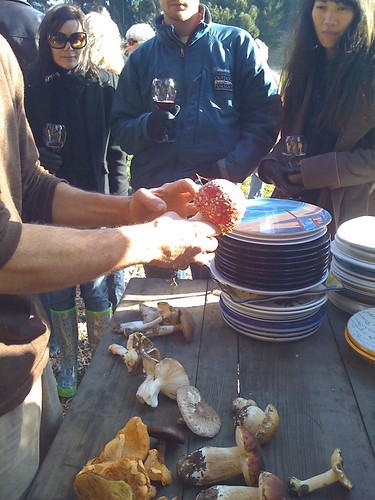
I went to a foraging dinner at Pie Ranch, where we took a walk to see mushrooms growing, and got an up close view of the red one with the white spots that is such a feature of German children’s literature, but is pretty poisonous.
I also attended a CAG meeting during this blogging break, where we started talking about land use. This is probably the area where we can make the most impact on the master plan process for the WPCP. We had a mini-charette where we split into groups, each with its own large-scale map of the plant lands and a pile of sticky notes to represent the acreage we’d devote to certain aspects. This time we discussed “social uses,” which means recreation. We were alloted an arbitrary 240 acres and 12 “dollars” to spend on different types of recreation, where a sports field complex, for example, cost 3 “dollars” and each inch of trail on the map 50 “cents.” (I don’t recall the scale of the map, but an inch was roughly 1/8 mile, I’d guess.)
There was broad consensus among the groups that a significant part of the budget should be spent on trails, but we weren’t entirely sure how other use of the plant lands would tie into park needs in North San José. The two other people in my group were in favor of sports fields, which I would support if there was a very pressing need in the area. The group with most of the environmentalists in it came out in favor of an educational farm (and I was pleased to hear the shout out the Veggielution got in the discussion of that) as well as an ADA-compliant playground further toward the Bay, with boardwalks to entice families with strollers to get closer to the water. The third group wanted smaller sports fields, and an interpretive trail as an educational component, as well as prioritizing a connection between the trails along the Guadalupe and Coyote Creek.
The members with detailed knowledge of where the sensitive habitat is located incorporated that information into their recommendations of where these park sites should be, but the rest of us will have to wait for the next meeting when we are set to talk about environmental uses of the plant lands. Ultimately, of course, there will be regulatory constraints on what can go where.